Banks and Epeiric Seas
Characteristics of Banks include:
Warm <20m
Cool 200-300m
Holocene-warm water
Modern warm water banks are typically isolated in large shallow waters and have steep faulted margins of >40 degrees. They are tide and wave dominated with occasional storm event having an impact on sediment transport. Coarse sediments are present where high-energy conditions exist while in shallow areas there are muds and pellet muds. Storm events and nearby islands modify circulation patterns which have a significant impact on the lithofacies of the following two examples
Example 1: Great Bahama Bank Facies.
The Great Bahama Bank encompasses an area of approximately 96000sqkm. The facies are asymmetric and have a sheet-like geometry, precipitous sides with a sharp facies gradient but broad, flat interiors. They include reefs on the eastern margin, a bank margin composed of coralgal and oolite sediments, and a bank interior composed of oolitic-grapestone, lime mud, and pelleted mud. Andros Island prevents the east-west movement of water across the bank. This area is characterized by muds and pellet muds. Overall the sediment is largely biogenic.
Example 2: Caicos Platform
Islands are located on northern margins with reefs in front. The banks are hit by waves causing good circulation throughout the region. Mud is localized to tidal flats on south side of the nearby islands. Everything else is skeletal grain and ooid sand.
Ancient-warm water
Example 1: Golden Spike reef in the Leduc formation
This formation has a platform rimmed by stromatoporoid reefs, with the platform interior composed of interbededded skeletal, sand flat grainstones and packstones and peritidal plana strombolites (ex. Triassic strata pictured below).
Holocene-cool water
These sites are typically covered in biogenic gravels and sands from bryzoa, molluscs, echiniods, corals and gastropods.
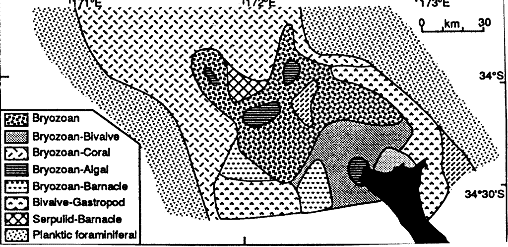
Example 1: Three Kings Plateau
The Three Kings Plateau is located off the northern coast of New Zealand, a site of active nutrient upwelling which is swept by vigorous wind, storm waves, and tidal currents. Facies belts are depth related resulting in a wide variety of biotic communities. The seafloor is covered by bryzoa/bivalve/ahermatypic coral sands and gravels with no mud. Active skeletal production is limited to inshore regions, areas of rough seafloor topography, and ridge and bank crests. Sediment from this site were most likely produced during low sea level stand.
Epeiric Shelves
There are no examples of epeiric shelves in the modern day so all of the following materials refer to ancient epeiric shelves. They existed during the highstand of Sloss super-sequences, when continents were deeply submerged.Characteristics of epeiric shelves include:
- Equable, relatively warm climates
- Vast, shallow (<10m), well-lit, clear seas
- Little exposed land
- Limited terrigenous influx
- Limited freshwater runoff
- Possible high evaporation rates (depends on latitude and geography)
- Sluggish circulation with deep ocean (frictional drag retards wind and tidal driving of currents)
- Good organic and carbonate productivity
-
There are at least two models that can be used to explain the conditions and the processes associated with ancient epeiric shelves. The following model assumes that tidal currents were not maintained across the platform because of the shallow water has a dampening effect. Circulation is rather restricted, only influenced by wind driven waves. Storm events play a major role in shaping the environment.
The Clear Water ModelZone X: offshore, subtidal shelf
- Open-ocean facing shelf with sediments deposited in sites ranging from inner to outer neritic
- Several hundreds of km wide
- Facies distributions follow depth-energy patterns similar to those of clastic facies
- Storm and fair weather waves dominate in low subsidence settings; Micrites better represented in rapidly subsiding settings
- Fauna and sediments are a mixture of locally derived (autochthonous) and transported (allochthonous) material
- Fabrics of in situ sediments reflect currents of removal
Zone Y: Banks and shoals
- Contrary to expectation from clastic shelves, highest energy facies (zone of shoaling and breaking waves) is located tens to hundreds of km ocean-ward of the strand line
- uctivity>Narrow zone some tens of km wide with Carbonate sand (calcarenite) shoals as dominant facies
- Sediment fabrics mimic those of clastic sands (bioclastic) reflecting dominance of local transport
- Micrite removed by currents
C. Zone Z: inner shelf.
- Protected, quiet water zone between shore and barrier shoal zone (Y).
- Tens to hundreds of km wide.
- Complex facies relations ranging from subtidal "lagoon" facies to intertidal mud flats.
- Salinity and fauna may range form normal marine to highly restricted (hypersaline) in cases of high evaporation or brackish in cases of high coastal runoff.
- Syngenetic dolostone & evaporites; diagenetic dolostone.
- Dolomite forms from high Mg++ brines.
- Syngenetic (chalky) dolostone assoc. with anhydrite/gypsum in hypersaline mud flats.
- Diagenetic (sucrosic) dolostone assoc. with unconformity and overlying evaporites: secondary brine alteration
Examples: Ancient eperic shelf successions include the late PreCambrian to Ordovician of China, the Cambro-Ordivician of North America, the Triassic to Jurassic of Europe, and the Tertiary of the Middle East.
Index to Carbonate shelf sediments