Ross Formation - Upper Carboniferous Deepwater Sediments
The Ross Formation outcrops along the shores of the Shannon Estuary from its south shore just south of Leck Point around to Loop Head to the north (figured in the photo heading this section), and then around the Atlantic flank of this peninsula to Fisherman’s Point. These exposures of this formation range from cliffs that can be viewed from a boat or small plane to rocky foreshores that are accessible from the nearby roads and fields. The quality of these outcrops makes it possible to examine the principal architectural elements of deepwater lobes and channels that form the Ross Sandstone. Similar outcrops of the overlying unstable slope sediments of the Gull Formation and the capping shallow water Tullig cyclothems are accessible too and the underlying basinal Clare shale can be seen north of Ballybunnion in Co Kerry (Fig. 1).
Fig. 1 Map of the Namurian outcropping around the axis of the Shannon Estuary.
The Ross Sandstone Formation is thickest in the area of south Clare (c. 380-460 m) and thins towards the north, east and south (Fig.2). It is primarily composed of sandstones (c. 65% at Loop Head; Chapin et al. 1994) with subordinate interbedded shales and slumped deposits of mixed lithology. A number of thin but laterally extensive 'marine bands' (at least nine although only three have been typed) also occur within the formation (Hodson, 1954a,b, and Hodson & Lewarne, 1961). These indicate that the duration of the Ross Formation may have been of the order of 500-900ky (Martinesen et al. 2008).
Fig. 2 North south cross-section of the Namurian outcropping across the axis of the Shannon Estuary.
The broad setting is one of a series of stacked, relatively small, sand-rich submarine fan systems. The sandstone beds are interpreted as a turbidites dispersed from an unseen source lying to the southwest and blanketing the deepest part of the basin floor. A submarine high in north Clare prevented all but the youngest of the flows from depositing sand there. The Ross Sandstone Formation is transitional with the overlying Gull Island Formation, with the boundary placed at the widespread Reticuloceras paucicrenulatum marine band (Fig.2).
Fig. 3 Details of the Namurian geology outcropping at Loop Head and across the axis of the Shannon Estuary at Leck Point (see Fig. 1 for color key to to geological formations). The place names listed are those associated with field localities illustrated in the attached galleries.
Ross Sandstone event beds
Fine-grained, structureless sandstones Beds, capped by thin rippled-laminated divisions dominate much of the Ross Sandstone Formation. Individual event beds are typically up to c. 30 cm thick (Elliot 2000a), although where amalgamated they can form sandstone units several metres thick in which there are cryptic amalgamation surfaces. Less commonly, the beds include evidence for dewatering (vertical dewatering pipes) and scour-and-fill laminations. The bed bases are sharp with common flutes and grooves, or load casts. These beds are interpreted as the deposits of sandy turbidity currents with high near-bed sediment concentrations and rapid suspension fallout. The limited textural range of the sand supplied to the basin (mainly fine sand) means the sandstone beds tend to be poorly graded.
Thin very fine grained sandstone beds (< 5 cm thick) are well laminated (parallel and dominantly ripple-laminated) and separated by silty mudstones generally a few cm thick. These sandstones are interpreted as relatively dilute turbidity currents, either small volume flows, or the dilute tops to larger flows stripped from nearby channels. Hybrid event beds are composed of a lower, paler, clean sandstone and an upper, darker-coloured, clay-rich sandstone, sometimes with mudclasts and sheared laminated sand patches. Some beds preserve evidence of banding. Hybrid event beds are common in the basal Ross sections at Ballybunnion and Inishcorker, and locally in the upper Ross Formation (e.g. at Kilbaha Bay). They represent deposition from flows that were differentiated along their length into front turbidity current and trailing ‘linked’ debris flow. The beds or units comprising abundant mudclasts are surrounded by relatively clean sandstone occur locally above erosion surfaces. The mudclasts can be relatively well rounded. These are interpreted as lags formed beneath bypassing and scouring currents.
Ross Sandstone Formation Depositional Elements
Fig. 4 Details of the Ross Formation elements outcropping around the axis of the Shannon Estuary. Click on the Hotspots
Detailed work on the Ross Sandstone Fm by several groups (e.g. Chapin et al. 1994, Elliot 2000a,b, Martinsen et al. 2000, Lien et al. 2003, Pyles et al. 2008) has established that the formation is comprised of a number of depositional elements (summarized in Fig. 4 above; click on the appropriate element to access outcrop example). The Ross formation is dominated by sheet-like sandy elements (mainly disorganized but also organized into upward-thickening cycles “TU” ), with subordinate channel-fills, channel wings, scour fills, and slump sheets. The sandier parts of the formations are subdivided by thin-Bedded local abandonment or ’repair’ elements, and by a series of m-scale condensed mudstone blankets. Lastly, there are prominent erosion surfaces decorated with large megaflutes. Whilst there is broad agreement on the types of depositional element in the Ross, the relationship between the different elements is less certain and has given rise to a number of different depositional models (see below).
Fig. 5 General depositional relationships of the Ross Formation elements within the interpreted fan systems outcropping around the axis of the Shannon Estuary.
The lower Ross is characterized by a greater abundance of sheet-like elements, whereas channels, channel complexes and overbank wings are more commonly seen in the central and upper part of the Ross. Intervening slump sheets are also more common in the upper Ross suggesting closer proximity to slopes. Megaflutes and erosion surfaces are common throughout.
Depositional models for the Ross Sandstone system
The architectural hierarchy of the Ross Formation shows a uniform system of channels which are distinguished from each other by abrupt lateral offset. Lien et al, 2003 studied the sea cliff exposures of the Ross Formation lining the Loop Head Peninsula in the
Shannon Estuary and the Atlantic. They identified
that the Ross Formation is composed of deepwater channels and associated sedimentary packages. At Kilbaha they report that
channels have northerly flow directions, whereas for the same stratigraphic
interval there are are easterly flow directions at Gull Island and Kilcredaun.
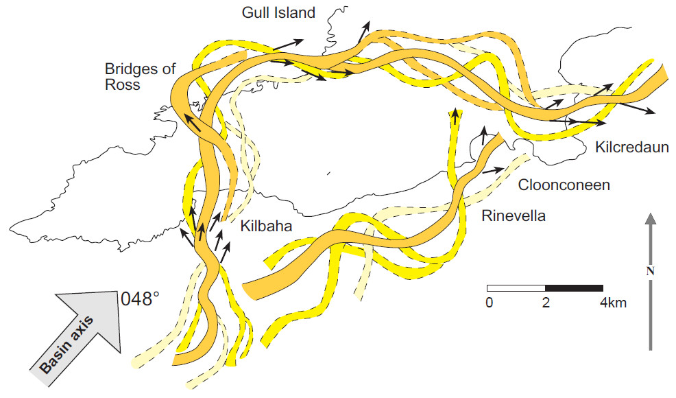
Fig. 6 The sinuous channel belts of the Ross Formation bisecting the Loop Head Penninsula (Lien et al, 2003).
A variety of depositional models have been proposed to account for the larger scale architecture of the Ross system. Most workers agree that the system shows a progradational to aggradational trend, punctuated by episodes of fan shutdown, with more sheet-like geometries at the base replaced upwards by a combination of shallow channels and sheets reflecting greater erosion and a more proximal position overall. This is consistent with the longer term basin-fill evolution from deep-water to slope to shallow water deltaic deposition. Early flows in the basal Ross Formation were characterised by hybrid rheology, but the bulk of the formation is characterised by conventional turbidites, albeit dominated by ungraded, largely structureless sandstone beds with ripple-laminated tops reflecting the limited grain size range of the input sediment. Many of the sheet-like beds higher in the formation are probably lateral wings to channels, implying the flows were able to overspill relatively easily. Shallow (a few metres to c. 10 m deep, up to a few 100 m wide) probably distributative channels lacking levees fed sediment to frontal and lateral splays.
Elliott (2000a,b) suggested the megaflute surfaces were key to understanding facies distribution. These surfaces were related to single large bypassing flows that carved megaflutes and through differential erosion created channels (Fig. t). These outsized flows presumably also deposited thick sands deeper in the basin. The channels created subsequently focused flows, promoting further erosion and preventing all but fine-grained overspill onto the megaflute surface (producing the so-called fine-grained ‘repair’ facies). As the channels filled, increasingly sandy parts of the flows were able to spread more widely, creating channel wings that thicken and become more sand-prone upwards.
Fig. 7 Elliott's 2000 depositional relationships of the Ross Formation megaflutes within the interpreted fan systems outcropping around the axis of the Shannon Estuary.
Lien et al. (2003) downplayed the significance of the megaflutes in channel initiation suggesting that they do not always occur on single surfaces. They also recognized common thickening-upward cycles in parts of the upper Ross and interpreted these as a combination of lateral channel migration (not a feature of the Elliott model) and again increased spillover as channels aggraded and filled (Fig. 8). The megaflutes were related to scouring produced at the channel margins, particularly where flows were overspilt to lateral splays or ‘spillover lobes’ as the channels filled. They also used detailed palaeocurrent measurements to infer that groups of channels and their spillovers occurred in sinuous belts emBedded in poorly packaged turbidites at the largest length scales.
Fig. 8 Lien et al. (2003) depositional relationships of the Ross Formation megaflutes within the interpreted fan systems outcropping around the axis of the Shannon Estuary.
A third model (Fig. 9) appeals to likely growth and retreat of distributative channel networks on the fan surface and recognizes that some of the sheets are frontal rather than lateral splays connected up-dip with channels. In this case, the megafluted surfaces would represent scouring in the channel-lobe transition zone (cf. Chapin et al. 1994). As they commonly occur beneath fine grained ‘repair’ facies, this suggests they are cut as the feeding channel is abandoned, perhaps in response to lobe aggradation to the point where it forces up-dip deposition and backfilling, allowing under capacity flows to accelerate across and scour the downdip splay. If correct, this would imply most of the sand is caught up-dip in the channels, and has not bypassed down-dip.
Fig. 9 Chapin et al. (1994) depositional relationships of the Ross Formation megaflutes within the interpreted fan systems outcropping around the axis of the Shannon Estuary.
Click on highlighted Deepwater Gallery for access to a complete index to images, maps, diagrams and photographs of deepwater geology including the geology of Co Clare.
Useful References
Chapin, M.A., Davies, P., Gibson, J.L. & Pettingill, H.S. (1994), Reservoir architecture of turbidite sheet sandstones in laterally extensive outcrops, Ross Formation, western Ireland. In Weimer, P., Bouma, A.H. & Perkins, R.F (eds), Submarine fans and turbidite systems, GCSSEPM Foundation 15th Annual Research Conference, 53-68.
Collinson, J.D., Martinsen, O. Bakken, B. and Kloster, A. (1991), Early fill of the western Irish Namurian Basin: a complex relationship between turbidites and deltas. Basin Research, 3, 223-242.
Davies, S.J. & Elliott, T. (1996), Spectral gamma ray characterisation of high resolution sequence stratigraphy: examples from Upper Carboniferous fluvio-deltaic systems, Co. Clare, Ireland. In Howell, J.A. & Aitken, J.F. (eds) High resolution sequence stratigraphy: innovations and applications. Special Publication of the Geological Society London, 104, 25-35.
Gill, W.D. (1979), Syndepositional sliding and slumping in the West Clare Namurian Basin, Ireland. Geological Survey of Ireland Special Paper 4, 31pp.
Hodson, F., (1954a), The beds above the Carboniferous limestone in north-west County Clare, Eire: Quarterly Journal of the Geological Society of London, v. 109, p. 259-283.
Hodson, F., (1954b), The Carboniferous rocks of Foynes Island, County Limerick: Geological Magazine, no. 2, p. 153-160.
Hodson, F. & Lewarne, G.C. (1961) A mid-Carboniferous (Namurian) Basin in parts of the counties of Limerick and Clare, Ireland. Quart. Geol. Soc. Lond., 117, 307-333.
Lien T., Walker, R. G., and Martinsen, O. J. (2003) Turbidites in the Upper Carboniferous Ross Formation, Western Ireland -
reconstruction of a sinuous channel and sandy spillover system, Sedimentology,
50, p113-148
Martinsen, O.J. (1989), Styles of soft sediment deformation on a Namurian (Carboniferous) delta slope, western Ireland Namurian Basin, Ireland. In Whatley, M.K.G. & Pickering, K.T. (eds) Deltas: sites and traps for fossil fuels, Geological Society Special Publication, 41, 167-177.
Martinsen, O.J. & Bakken, B. (1990), Extensional and compressional zones in slumps and slides in the Namurian of County Clare, Ireland. Journal of the Geological Society, 147, 153-164.
Pulham, A.J. (1987), Depositional and syn-sedimentary deformation processes in Namurian deltaic sequences of west County Clare, Ireland. Unpublished PhD thesis, University of Wales, Swansea.
Pulham, A.J. (1989), Controls on internal structure and architecture of sandstone bodies within Upper Carboniferous fluvial-dominated deltas, County Clare, western Ireland. In Whatley, M.K.G. & Pickering, K.T. (eds) Deltas: sites and traps for fossil fuels, Geological Society Special Publication, 41, 179-203.
Pyles, D.R. (2008), Stratigraphic architecture of a structually confined submarine fan, Carboniferous Ross Sandstone, Western Ireland, Bulletin of the American Association of Petroleum Geologists. V. 92
, No. 5, P. 557
–
587 .
Rider, M.H. (1969), Sedimentological studies in the West Clare Namurian Basin, Ireland and the Mississippi Delta. Unpublished PhD thesis, Imperial College London.
Rider, M.H. (1974), The Namurian of West County Clare. Proceedings of the Royal Irish Academy, 74B, 125-142.
Rider, M.H. (1978), Growth faults in the Carboniferous of western Ireland. Bulletin of the American Association of Petroleum Geologists, 62, 2191-2213.
Sevastopulo, G.D. (1981), Upper Carboniferous. In Holland, C.H. (ed.) A geology of Ireland. Scottish Academic Press, 173-199.
Wignall, P.B. and Best, J.L. (2000), The Western Irish Namurian Basin reassessed. Basin Research 12, 59-78.
Wignall, P.B. and Best, J.L. (2002), The Western Irish Namurian Basin reassessed – a discussion. Basin Research 14, 523-542.