- LST: Major siliciclastic bypass occurred at the GP2 boundary and resulted in the Delaware basin with the accumulation of the Brushy Canyon formation and the Cherry Canyon Tongue Member. On the shelf the LST is represented by a prograding complex onlapping the underlying HST shelf margin of GP1.
-
TST: thin series of shoaling-upward ooid-rich and peritidal parasequences and bioherms on the shelf margin. In the slope, these bioherms are overlain by later transgressive siliceous dolomudstones and sandstones.
-
HST: a series of shallowing upward carbonate parasequences 40-70 m thick that prograded into the basin for 2-5 km as a series of sigmoidal to oblique clinothem units that encompass a depth range of over 200 feet.
Guadalupian-3 (GP3)
Guadalupian-4 - Guadalupian-10 (GP4-GP10)
These sequences represent the regressive highstand of the Guadalupian supersequence. At this time progressive progradation transformed the basin geometry from a gentle ramp to submerged, rimmed shelves with foreslopes that attained angles of 35o-40o. Sand and silt bypassed shelf areas during lowstands and formed the Basin-restricted siliciclastics of the Cherry Canyon and Bell Canyon formations. These 3rd-order sequences are comprised from the base upward of the Queen, Seven Rivers, Yates, and Tansill formations on the shelf, and Goat Seep and Capitan formations on the shelf-edge reef complexes, and the Cherry Canyon and Bell Canyon formation sequences in the Basin. The Guadalupian supersequence was ended by the evaporative drawdown of the Castile and Salado formations, the subaerial exposure of the shelf and the termination of carbonate deposition.
Kerans and Kempter (2002) high frequency depositional model
As indicated in chapter-2, the Kerans and Fitchen (1995) and Kerans and Kempter (2002) schemes involve subdividing the Guadalupian stratigraphic section into composite sequences (CS), which have a comparable duration to third-order sequences. Each CS is subdivided into high frequency sequences (HFS), which may be equivalent to fourth-order events. Each HFS consists of systems tracts and HFS cycle sets. Each HFS cycle (fifth-order parasequence) represents a sea level rise and fall. The boundaries of the HFS were identified on the basis of a subaerial unconformity and/or a karstification event; the turn around from progradation to retrogradation cycles; a major Basin-ward shift of offsets in location of facies tracts across a single surface; and/or a systematic trend in the thickness of facies proportion of cycles (upward thickening of cycles during base level rise followed by upward thinning to a sequence boundary during the next sea level fall).
The HFS's are specific to the depositional setting in which the section is found. For example, Upper San Andres high frequency sequences are found only on the shelf and are represented by the highstand systems tracts of CS-10 Guad-10, while the Brushy Canyon is found only in the basin and is represented by the lowstand systems tract of CS-10 Guad5-7. The most Upper Leonardian and Guadalupian section consists of six composite sequences (from lower to upper: CS-9 to CS-14).
Kerans and Fitchen (1995) defined facies tracts as linkages of associated depositional environments developed within discrete energy/water-depth regimes that include the inner ramp, middle ramp, ramp crest, outer ramp, distal outer ramp, etc. Below a short summary is provided of the major facies tracts of the Permian Basin:
Inner ramp: occupied by evaporates and siliciclastic and carbonate mudstone, and representing the most landward marine extent of the platform.
Middle ramp: represented by a lagoon filled with mud rich and peloidal carbonates dominated by very shallow subtidal to intertidal settings.
Ramp crest: the seaward limit of the ramp crest facies tract is the intersection of fair-weather wave base with the ramp profile. This is the highest energy facies tract on the ramp and is critical to tracking platform evolution. In Guadalupian-age restricted platform, ooid and peloid shoals are the dominant facies; the skeletal shoals are representative of open-marine conditions and are characteristics of Leonardian-age San Andres formation.
Outer ramp: extended from fair-weather wave base (approximately 30 ft water depth) to 300-400 ft water depth. The outer ramp is the clinoform part of the depositional profile and can vary significantly in the terms of slope angle and lower water depth limit depending on accommodation and sediment supply.
distal outer ramp: the clinoform-toe setting was dominated by carbonate mudstones or siliciclastic siltstones.
These composite sequences are in part subdivided into a total of thirty-two high frequency sequences (Leonardian 5-8 and Guadalupian 1-28).
composite sequence 9 (CS-9)This composite sequence is represented by the Lower-Middle San Andres sequence on the shelf and the Cutoff formation in the Delaware Basin. The G1-G4 sequence set represents a HST: here distal outer ramp sediments of this prograding phase of platform development are characterized by deeper water carbonate mudstone that are commonly cherty and organic-rich. Outer ramp cycles are of fusulinid wackestones that coarsen upward into crinoid-fusulinid peloidal packstones. Ramp-crest facies are characterized by high-energy associations of crossBedded ooid-peloid grainstones and the associated massive and bioturbated lateral equivalents. Middle-ramp facies are mudstones, wackestones, and packstones containing peloids and dasyclads.
L5-L6 HFS: represents the lowstand systems tract (LST) of CS-9 and consists of the Yaso formation of the Upper Leonardian. It is composed of silty tidal-flat carbonate, which is equivalent in the subsurface to the Clear Fork and the Glorieta formations which collected as a Basin-ward progradational event. The Cutoff Ridge formation is the equivalent in the outer shelf to slope (Lower and Middle Victorio Peak and Bone Spring formations). The best exposure for these sequences is found in the Algerita Escarpment and the Cutoff Ridge.
L7 HFS: represents the transgressive systems tract (TST) of CS-9 when a major and abrupt global transgression took place. This is represented by a thick stack of as much as 550 ft of retrogradational, aggradational, and progradational cycle sets. They form a widespread blanket of relatively normal-marine facies across the Permian Basin. The depositional profile of the basin is a gentle ramp. The facies include assemblages of subtidal skeletal wackestones, packstones, and grainstones. The best exposure for this sequence is found in the Western and Algerita Escarpments and in the Rio Penasco area and Hondo Valley. L7-L8 sequences can also be observed in the Shumard and Bone Canyon of the Delaware Basin.
L8 HFS: represents a continuously deepening transgressive systems tract (TST) of CS-9 and a continuation of shallow-shelf open-marine carbonate deposition. The depositional profile of the basin is of a broad distally steep ramp with minor local ramp crest facies tracts composed of bioclastic grainstones. The outer ramp and ramp crest facies consist of bioclastic packstone and grainstones with diverse open marine fauna. Updip, the carbonate retrogradational cycle sets are capped by progradational cycle sets dominated by evaporite sediments.
G1 HFS: represents maximum flooding and highstand systems tract (HST) of CS-9 and an aggradational and progradation of the ramp. The inner shelf facies consist of evaporites, the middle shelf consists of evaporite and carbonate mudstone, the ramp crest consists of ooid-peloid, the outer shelf consists of fusulinid-rich carbonates while the slope and basin consist of the mudstones of the Cutoff formation. The best exposure for this sequence is found in the Western Escarpment and Lawyer and Algerita Canyons on the Algerita Escarpment.
G2 HFS: represents highstand systems tract (HST) of CS-9 and the progradation of a gently dipping ramp.
G3 HFS: represents highstand systems tract (HST) of CS-9 and the progradation of a gently dipping ramp. This sequence displays a sigmoid clinoform style with some steeper ramp dipping.
G4 HFS: represents the highstand systems tract (HST) of CS-9 and the greatest progradation of all previous sequences. G4 upper boundary has a well-developed karst profile with collapsed Breccias. This contact is also the bypass surface across which the lowstand sequence set of the Brushy Canyon Basinal sandstones were transported.
composite sequence 10 (CS-10)
This composite sequence is represented by the Upper San Andres formation on the shelf and the Brushy Canyon formation in the Delaware basin and creation of a steeply dipping profile and the transition from a ramp to rimmed profile in CS-11.
G5-G7 HFS: represents the lowstand systems tract (LST) of CS-10 and the deposition of the Basin-restricted siliciclastics of the Brushy Canyon formation in the Delaware Basin. Landward, channel stacking was evident in the G7 HFS.
G8 HFS: represents the transgressive systems tract (TST) of CS-10 and the aggradation of shelf carbonate accumulations. The lower boundary of G8 is a sharp flooding of lower energy above G4 on the shelf. The upper boundary is the basal G9 sandstone.
G9 HFS: represents the highstand systems tract (HST) of CS-10 and the deposition of the Upper San Andres formation on the shelf. The LST of G9 is represented by a sandstone wedge on the floor of the Delaware basin (basal of the Cherry Canyon formation). The TST of G9 is represented by fine grains of the Cherry Canyon Tongue in the shelf and Basin. The HST of G9 HFS is represented by a mixed clastic-carbonate clinoforms with sigmoidal profile evolving into oblique profile as sea level continued to fall. The upper boundary is a well-developed karst surface with vadose profile. The best exposure of this section is found in the Last Chance Canyon.
composite sequence 11 (CS-11)
This composite sequence is represented by the Grayburg and the Queen formations on the shelf, the Goat Seep dolomites on the shelf margin and foreslope, and the Cherry Canyon formation in the Delaware Basin. This composite sequence marks the complete transformation of the basin from a ramp to rimmed profile.
G10 HFS: represents a lowstand prograding wedge of mixed clastic-carbonate strata which is developed only downdip and the deposition of the Lower Grayburg formation. The relative sea level fell by as much as 140'. The inner ramp crest is represented by fenestral fabric facies, the outer ramp crest is of high-energy grainstones (ooids), and the outer ramp consists of fusulinid-rich facies with high degree of dipping (3 o -17o). The best exposure of this section is found in south of Algerita Escarpment.
G11 HFS: represents the transgressive systems tract (TST) of CS-11 and the continual deposition of the Grayburg formation. The outer ramp facies tract consists mainly of fusulinid-rich packstone.
G12 HFS: represents the initial highstand systems tract (HST) of CS-11 and display only minor sea ward progradation of facies. The outer ramp crest facies consist of lower-energy grainstone complex while the outer ramp facies consist of fusulinid belt truncated by pre-Goat Seep surface. The best exposure of this section is found at the Plowman Ridge, West Dog Canyon, and Cutoff Ridge.
G13 HFS: represents the highstand systems tract (HST) of CS-11 and the lower of the Queen HFS. It consists of siliciclastic and thin carbonate mudstone. The ramp crest facies belt is represented by fenestral-laminate cycles, the outer-shelf is mostly fusulinid-dominated packstone, while the basin consists of the sandstones of the lower Cherry Canyon formation. The best exposure of this section is found in the Shattuck Valley Escarpment and on the northern exposure of the Western Escarpment.
G14 HFS: represents the highstand systems tract (HST) of CS-11 and the upper of the two Queen HFS. The first true reef-rimmed platform became evident in the Guadalupe Mountain region and is represented by the shelf-margin reef complex of the Goat Seep and the Cherry Canyon. The shelf-crest to basin relief is of 1,700 ft. The shelf crest facies consist mainly of stacked tepee-pisolites and reef faunas. The best exposure of this section is found in the middle and southern Shattuck Valley walls and Western Escarpment, Goat Seep reef and Bush Mountain of Western Escarpment, and south McKittrick Wind Gap section.
composite sequence 14 (CS-12)
This composite sequence is represented by the Shattuck member of the Queen formation and the Seven Rivers formations on the shelf, the Capitan Massive was deposited on the shelf edge while the Capitan slumps are found on the slope, and the Upper Cherry Canyon and Lower Bell Canyon formations deposited in the Delaware Basin. This composite sequence consists of G15-G20.
G15-16 HFS: represents the lowstand systems tract (LST) and early transgressive systems tract (TST) of CS-12. G15 represents the LST of CS12 and it is manifested by a lower progradational half of the Shattuck member of the Queen formation and the Cherry Canyon sandstones in the Basin. G16 represents the early TST of CS12 in which the Manzanita member of the Cherry Canyon formation was deposited in the basin and the upper Shattuck sandstone on the shelf. The best exposure of this section is found in the Manzanita road cuts near Route 62-180 and at the base of the Guadalupe Peak cliff face on the Western Escarpment.
G17 HFS: represents the second transgressive systems tract (TST) of CS-12. This is the 1st of 12 "Capitan" high frequency sequences. It consists of the Lower Seven Rivers formation on the shelf, the Lower of the Capitan Massive on the shelf edge, and the Lower Bell Canyon formation in the Basin. The total shelf crest to toe-of-slope relief is 1,550 ft. The inner shelf facies belt consists of siliciclastics and mudstone/gypsum, the middle shelf consists of siltstone-carbonate-mudstone, the shelf-crest consists of retrogradational stacking of mudstone-skeletal packstone with fenestral laminite, the outer shelf consists of mollusk-skeletal packstone, the shelf margin consists of progradational stacking reef in 100-200 ft water depth, and the slope consists of Breccias and debris flow (gradational upward into reefal facies and pass downward into toe-of-slope mudstone and fine-to-medium-grain siltstones of the Bell Canyon formation. The best exposure of this section is found in the north walls of McKittrick Canyon and the north walls of Slaughter Canyon.
G18 HFS: represents another transgressive systems tract (TST) of CS-12 with less progradation than G17. The shelf crest to toe-of-slope relief became steeper (1,600 ft). The sequence has well developed Basinal mudstones of the Bell Canyon formation in the Delaware Basin. The best exposure of this section is found in the McKittrick Canyon and the Slaughter Canyon.
G19 HFS: represents a turn a round (maximum flooding) and highstand systems tract (HST) of CS-12 with increased steepness of the shelf edge and decrease in accommodation on the shelf.
G20 HFS: represents the highstand systems tract (HST) of CS-12 and the deposition of the Seven Rivers formation on the shelf. The reef margin shallowed drastically (from 100 ft to 50 ft) with progradation of shelf-crest fenestral complex Basin-ward.
composite sequence 13 (CS-13)
This composite sequence is represented by the deposition of the Lower Yates formation on the shelf, the Middle Massive Reef on the shelf edge, the Capitan Bedded on the slope, and the continuation of the Bell Canyon in the Delaware Basin. This composite sequence consists of G21-G24.
G21-22 HFS: G21 is a small lowstand wedge resolvable at the shelf margin. G22 is the first HFS of the Yates formation on the shelf (transgressive systems tract - TST). The best exposure of this section is found in the northern McKittrick Canyon and the Slaughter Canyon. The Upper Yates is exposed in Walnut and Dark Canyon.
G23-24 HFS: represents the highstand systems tract (HST) of CS-13 (Yates formation). The shelf-crest to toe-of-slope relief started to decrease to 1,300 ft. The basin deposits consist of the lower and upper Rader member of the Bell Canyon formation which consists mainly of carbonate mega Breccias with sandstone matrix. The best exposure of this section is found in the McKittrick Canyon and the Slaughter Canyon.
composite sequence 14 (CS-14)
This composite sequence is final Guadalupian sequence and marks a turn around to more regressive deposits. It is represented by the deposition of the upper Yates formation and Tansill formation on the shelf, the Upper Massive Reef on the shelf edge, the Capitan Bedded on the slope, and the continuation of the Bell Canyon in the Delaware Basin. This composite sequence consists of G25-G28 HFS's.
G25-26 HFS: represents the transgressive systems tract (TST) of CS-14 the deposition of the Upper Yates and Lower Tansill on the shelf. The platform aggradational deposits are represented by shallowing upward cycles. G25 is correlated in the basin with McCombs member of the Bell Canyon. G26 is represented by the upper most of the Yates formation on the shelf and includes the Triplet sandstones of the uppermost Yates formation. The shelf-edge facies consist of aggrading tepee-pisolite complexes and shallow-water shelf-margin reefs. The best exposure of this section is found in the McKittrick Canyon and the Slaughter and Rattlesnake and Walnut Canyons.
G27-28 HFS: represents the final sequences of the Guadalupian section and contains the highstand systems tract (HST) of CS-14. The Lower Tansill was deposited by G27 while the Upper Tansill was deposited by G28. Ocotillo siltstone member separates the lower Tansill from the upper Tansill and represents a lowering of sea level. The best exposures of this the Tansill-age reef are found in the Walnut and Dark Canyons.
As indicated above, the Permian basin profile and sedimentary section can be classified into different facies tract representing different environments of deposition formed as a result of their paleobathymetry and the resultant water depth. There follows a brief description of the Permian basin Formation');">Formations. Generally, these are direct result of the reciprocal sedimentation model in which carbonates deposit on the shelf, reefs deposit on the edge, and clastics deposit in the Basin.
Sedimentary Section of the Shelf
Shelf deposits occur in widespread sheets or lenses. Shelf carbonates comprise the San Andres, Grayburg, Queen formations and the Carlsbad Group . All of these shelf formations grade up-dip into siltstones, evaporites, and dolomites representing sabkha, playa, and lagoon deposition. Shelf dolomites and siltstones contain higher average porosities than shelf-marginal or Basinal strata, and account for most of the hydrocarbon reserves of the Permian Basin. Porosities in the subsurface occur primarily as intercrystalline and moldic porosities in the dolomites and as preserved primary porosities in the siltstones (Ward et al., 1986).
The shelf carbonates of the San Andres, Grayburg, Queen formations and the Carlsbad Group form shoaling upward sequences. Close to the shelf margin these are mainly keep-up grainstone sheets that aggraded just landward from the shelf break along basin margins during sea level highstand. In the San Andres formation these sheets were formed as repetitive shoaling-upward platform parasequences, which terminated in aggrading and prograding tidal-flat and lagoonal-fill. These parasequences were punctuated by periodic variations in eustatic position. The grain carbonates of these formations occur at the top of shoaling-upward sequences and retain their depositional porosity. Their rates of accumulation are interpreted to have matched the rates of sea-level rise. These formations were sealed by up dip by highstand tidal-flat evaporites.
In contrast to the San Andres formation, the Grayburg, Queen formations and the Carlsbad Group form sheets of repetitive shoaling-upward platform parasequences that were altered by diagenesis and cementation to a dolomitized pisolitic tepee barrier island facies.
As with the parasequences of the earlier Sand Andres margin these facies are punctuated by periodic variations in eustatic position. The pisolitic carbonates of these upper formations occur at the top of shoaling-upward sequences and contain a mix of depositional and diagenetic porosity. Their rates of accumulation are interpreted to have matched the rates of sea-level rise. As with the San Andres formation these upper formations were sealed by up dip highstand tidal-flat evaporites.
The primary lateral and overlying seals are porosity and permeability barriers formed by the precipitation of updip sabkha and playa evaporates in the pores of the originally porous dolomites and sandstones.
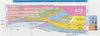
Following is a brief description of the shelf formations (please refer to the cross section above).
San Andres formation
San Andres formation was named from its type section in the San Andres Mountains of New Mexico. Typically the basal member of the San Andres consists of dense zone of dolomite. Above this zone, in the center of the San Andres belt on the Central basin platform and the Northwestern shelf, the formation consists of limestone which is up to several hundred feet thick and grades upward and away from the reef into crystalline dolomite. The texture of the dolomites becomes finer on the Northwestern shelf as the proportion of chemically precipitated dolomite increases, and anhydrite becomes present the section, first as small blobs, then as beds (Jones, 1953).
Most workers divide the San Andres formation into two shoaling upward third-order sequences that are tied to the occurrence of a regionally correlatable thin siltstone marker bed known as the "Pi" marker (Harris and Stoudt, 1988). Ross and Ross (1995) attributed this thin shelfal sandstone to a region-wide unconformity and assigned this member to the Cherry Canyon Tongue. In the Northwest Shelf, Sarg and Lehmann (1986) recognize that each of the San Andres third-order sequences as comprised of a LST wedge deposited in the Basin, a TST clastic or carbonate belt that shifts landward, and in the following HST mostly carbonate deposition on the shelf. Other workers including Sarg et al. (1999) and Kerans and Fitchen (1995) subdivided the San Andres formation into three 3rd-order sequences, a lower and middle San Andres. These are separated from the upper San Andres by the Cherry Canyon Tongue.
Kerans and Kempter (2002) subdivided the lower San Andres composite sequence into six high-frequency sequences (HFS) (L7-L8 transgressive sequences, and G1-G4 highstand sequences) with the upper San Andres composite sequence consisting of five HFS's which include the Basinal Brushy Canyon formation deposited during the sea level lowstands and the carbonate sections of the shelf deposited during sea level highstands (G5-G9).
Beserra and Dorobek (1995) identified three depositional settings in the Sacramento Mountains outcrop of the San Andres formation that deposited eleven lithofacies in peritidal, shallow-subtidal, and deep-subtidal environments.
Peritidal lithofacies: includes medium-to-fine-grained sandstone, siltstones to very fine-grained sandstone, and pisolitic-fenestral dolograinstones/wackestone. These lithofacies are commonest in the lower parts of San Andres just above the contact with the Leonardian Yeso formation.
Shallow-subtidal lithofacies: includes peloid dolomudstones/wackestone, ooid-peloid-intraclast dolograinstones, skeletal-peloid dolograinstones/packstone, and peloid dolopackstones/grainstone. These are the dominant lithofacies of the San Andres formation and represent shelfal transgressive and highstand deposits.
Deep-subtidal lithofacies: includes peloid-skeletal dolowackestone/mudstone, peloid dolomudstone/wackestone, and dolomudstones. These lithofacies are mud-rich, thin-Bedded, and poorly fossiliferous facies that accumulated in a low energy setting below fair-weather wave base. These lithofacies are not very common.
Grayburg formation
The Grayburg formation was described by Dickey in 1940 from a dry hole near the Grayburg field of Eddy County, New Mexico. Here this formation is 299 feet thick. It consists of dolomite, with sandy dolomite and red and gray sandstone at the base, middle, and top, and a little anhydrite. Farther from the Capitan Reef the dolomite grades to anhydrite, and eventually into sand in west central Texas (Jones, 1953).
Queen formation
The Queen formation was named by Blanchard and Davis in 1929 for the outcrop in the vicinity of Queen post office, 30 miles southwest of Carlsbad. The upper part of the formation is in most places sand with numerous, large, frosted grains. The rest of the formation also contains much sand, accompanied by dolomite, anhydrite, or salt. dolomite is commonest at the base, and in the middle (Jones, 1953).
Seven Rivers formation
Named by Meinzer, Renick, and Bryan in 1926 based on its type locality northwest of Carlsbad. The Seven Rivers consists mostly of gypsum with some red sandstone, shales, and dolomite. Farther from the reef, the anhydrite grades into salt so that in the eastern part of the Midland basin the Seven Rivers is predominantly salt. (Jones, 1953)
Yates formation
The Yates formation was named by Cartwright and Adams in 1929 from wells in the Yates field at the southern tip of the Central basin platform. It consists primarily of gray and red sand with some beds of dolomite and shales. The sand is gray and is interBedded with dolomite near the Capitan Reef while it's red farther landward where it is associated with supratidal anhydrites and salt (Jones, 1953).
Tansill formation
The Tansill formation is name for its type locality north of Carlsbad, Eddy County, New Mexico, where it consists primarily of dolomite and few thin beds of sands (Jones, 1953). The Tansill formation is the upper most carbonate section of the Guadalupian series on the shelf region. It's overlain by the evaporites and red beds of the Ochoan and Salado formation (Parsley, 1988). Jones (1953) indicated that the Tansill grades Basinward into the top of the massive Capitan Reef while further back from the reef it grades into anhydrite and finally into equal parts of anhydrite and salt.
Sedimentary Section of the Shelf Edge
Goat Seep dolomite
The Goat Seep shelf-edge limestone consists of massive or thick-Bedded limestones similar to the Capitan limestone, but of pre-Capitan (middle Guadalupe) age, which crop out in the Guadalupe Mountains (King, 1948). King took this name from the "Goat Seep," in 1948 on the west slope of the mountains 112 miles northwest of Guadalupe Peak. The Goat Seep dolomite interfingers with the sandstones of the Cherry Canyon formation in the Delaware basin to the southeast and overlies the Grayburg carbonates on the shelf.
The Goat Seep facies have been interpreted as the reefal phase of a major shelf margin carbonate mass, which formed in a submerged shelf-edge position on the edge of the Delaware basin in water depths in excess of 20-30 m. These shelf-edge facies of the Goat Seep were deposited on slopes of 25o-30o and consist of a mixture of autochthonous and allochthonous shelf and shelf-edge derived sediments (Crawford, 1981).
Capitan Reef
G. B. Richardson named the Capitan limestone in 1904 with its type locality being on Guadalupe Peak - El Capitan. According to (King, 1948), the formation includes the thick-Bedded or massive white limestones of reef facies and upper Guadalupe age, that crop out in the Guadalupe Mountains. The reef grew southeastward (Basinward) over the shelf-edge Goat Seep formation and was time-equivalent of the shelfal Seven Rivers, Yates and Tansill formations (Ross and Ross, 1995). Most of the reef is composed silt sized carbonate (Kendall, 1969) but locally it contains interlocking algae and sponges that were deposited just below the water surface (Jones, 1953). Kerans and Tinker (1997) assigned the Capitan Reef to the last three composite sequences (the last 12 HFS's of CS12-CS14) of the Guadalupian and it consists of transgressive and highstand catch-up and keep-up reefs.
Salado formation
The mostly salt-bearing Lower Ochoan Salado formation contains the thickest beds of salt in the west Texas Permian section. Lang (1935) named it for the type locality - Salado Wash in Loving County, Texas. It contains numerous potash beds and some interBedded layers of anhydrite, and thin beds of dolomite. The Salado formation occurs both in the basin overlying the Castille formation and extends to the shelf overlying the Tansill formation. The maximum thickness of the formation in the Delaware basin is somewhat more than 2,000 feet. In the shelf areas, north and east of the Basin, it is 1,000 feet or less (King, 1948).
The evaporitic Castille formation of the Ochoan caps the Bell Canyon. Sediment for the sandstones was probably transported from the shelf to the basin by gravity-driven currents, whereas the limestones represent slumps and turbidites of shelf-margin and slope carbonates (Ward et al., 1986).
Brushy Canyon formation
The Brushy Canyon formation is situated at the base of the Permian strata of the Delaware basin and rests on the Leonardian shaly Cutoff formation. It consists primarily of "thick, yellowish sandstones with rather distinct shale partings" and is capped by massive yellow or brown ledges coarser grain sandstone (King, 1948) (figure above). It's deposited as lowstand slope and Basinal clastics that filled the Delaware basin and transgressed over the Cutoff formation and reached as high as the shelf margin (Ross and Ross, 1995).
Cherry Canyon formation
The Cherry Canyon formation is situated between the Brushy Canyon formation below and the Bell Canyon formation above of the Permian strata of the Delaware Basin. It consists primarily of "brownish, rather bituminous shales, with limestones and some sandstones". In outcrop, the Cherry Canyon formation commonly has a nearly constant thickness of 1,000 feet, but east-southeast of El Capitan this thickness increases to 1,283 feet (King, 1948).
Most of the deposition of the lower Cherry Canyon clastics probably took place during the hiatus at the end of San Andres deposition when sea level fell and the carbonate Rocks of the Central basin platform were eroded by dissolution, leaving no coarse debris to accumulate in the adjacent basin (Hills, 1972).
Bell Canyon formation
The Bell Canyon is the uppermost formation of the Delaware Mountain Group and the Guadalupe series and is succeeded by Castile formation evaporites. The formation has a maximum thickness of between 670' to 1,040' and is composed of sandstone, with some thin, dark-gray limestone Beds. It consists of "very thick sandstones, alternating with less thick limestones, and rather hard shales" (King, 1948). In the northwest, in the Guadalupe Mountains, the Bell Canyon changes into the white, massive Capitan limestone, which forms a 1,500 to 2,000 feet thick reef mass. The formation inter-grades with the reef mass of the Capitan limestone in the Guadalupe Mountains.
Castille formation
The mostly anhydrite-bearing base of Ochoan Castile formation is the cap Rock and seal for the underlying Bell Canyon in the Delaware basin and sloping surface of the Capitan limestone along its margins and the overlying red beds and evaporites of the Salado formation. The Castile formation was named by G.B. Richardson in 1904 for Castile Spring type locality. The formation consists mostly of gypsum, that has altered from anhydrite, with the upper beds consisting of salt. It has a maximum thickness of between 1,500 and 2,000 feet (King, 1948). The deposition of this formation resulted from the drastic lowering of eustatic sea level below the shelf margin and the restriction of the Delaware basin (Ross and Ross, 1987).
Conclusions
The Permian basin is characterized by a progressively shallowing upward character. The depositional profile of the basin reflects this shallowing trend with the change from the initially open distally steepened ramp, into a restricted sigmoid-progradational ramp, an exposed platform, transitional ramp to rimmed shelf, and finally into mixed clastic-carbonate reef-rimmed shelf. This follows an increasing steepening of the shelf-margin directly resulting from basin starvation and the intial basin topography coupled with the shallowing trend. The latter caused the shelf-margin deposits to keep-up with rising sea-level, while basin starvation caused the margin to steepen as it prograded Basin-ward. Superimposed on the shoaling upward cycles are the effects of glacial eustasy common to the Upper Permian.
lowstand systems tract (LST)
The lowstand systems tracts of the Permian basin are the product of a lowering in the relative sea level and occasional exposure of the peritidal region or even the shelf margin sections of the Basin. The result was deposition of Basinal linear channel sandstones in the basin beyond the shelf margin through deposition of aeolian siltstones by means of shelf bypass. The margin slope is characterized by carbonate slumps that were derived from the exposed shelf margin facies. The shelfal LST lithofacies are identified in some parts as onlapping the shelf margin carbonates and by prograding downslope sandstone tongues moving southward toward the Basin. The tidal flats LST contain mostly aeolian sandstones and siltstone overlying the underlying supratidal lithofacies of the vertically adjoining TST & HST. The basin fill is generally composed of thin carbonate beds alternating with sandstone and siltstone onlapping the shelf with thick beds of sandstone in the Basin
transgressive systems tract (TST)
transgressive systems tracts resulted from abrupt deepening of the basin and gradual reestablishment of carbonate production. Therefore, the TST facies are primarily identified on the basis of the deepening-upward of the lithofacies succession. This change occurred throughout the basin but is most pronounced at the shelf margin as the carbonate factory is turned on and kept-up with rising sea level. Gradual retrogradational depositional patterns became established as the carbonates accumulated on underlying the LST sandstones in the basin and slope as thin layers of burrowed wackestone and even oxygen-poor lime mud in the deepest part of the Basin. The tidal flats TST are characterized by supratidal facies of arid and hot settings including fenestral pisolitic dolomudstones and dolopackstones. The basin is generally characterized by thicker beds of carbonates on or close to the shelf with the shelf margin becoming steeper and sandstone beds in basin becoming thinner.
highstand systems tract (HST)
The highstand systems tracts were established as a result of a slowing down in the rise of relative sea level. They are marked by keep-up carbonate production on the shelf margin and domination of carbonate deposition throughout the Basin. The HST sequences are generally shoaling upward parasequences that gradually changed from aggradational during early HST to progressively progradational as a result of accommodation space being filled. The general lithofacies distribution of the HST is of thick beds of carbonates on shelf and shelf margin and very thin beds of sandstone on basin and slumps on slope. The parasequences progressively become more restricted toward end of sequence with evaporite beds precipating in basin as a result of restriction and red beds accumulating on the shelf.