Depositional settings, source terrains of deepwater fans and mass transport debris
Introduction
The block diagrams above capture the general change in character of clastic submarine fans as they respond to changes in source terrain and so grain size. To view a larger image of any of these fans click on the hot spot over that fan to view them individually.
For examples of views of real fans you can link to images of the Los Angeles Margin and Basin by clicking on the oval diagram above heading this section.
The most abundant and thickest of these sedimentary features are deepwater fans and associated gravitationally driven mass movement deposits. These in turn are formed by non-cohesive flow sediments (including high frequency turbidites), mass movement debrites and pelagic drapes. These collective sedimentary building blocks are categorized on the basis of:
- Their often uniform and cyclic vertical composition
- Contact Boundaries
- Amalgamation
- Stacking
- Variations in lateral thickness of their geometries
- Whether these bodies are:
- Confined within eroded or constructed depressions
- Unconfined sheet
These architectural relationships are used to interpret of the general depositional settings of these sediments and how they were linked together through space and time.
Click on image above to link to larger scale version of this cartoon
The architectures expressed by the sediments of deep-water settings are tied directly to the source terrain, the terrain of the depositional setting and the character the deepwater processes involved in that deposition. All of these factors may vary over a wide range of time scales for any specific locality and without careful and detailed study of the specifics of the local stratigraphy it often is difficult to be certain of the distribution of the reservoir quality sediment and their character.
Source Terrain
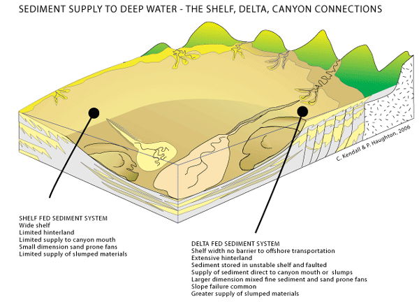
The physical character of the catchment area that supplies the deepwater system has a significant impact on the rates of sediment supply, and the nature of the sediment. Controlling properties (see figure above too) include:
- Topography - the greater the relief the greater the sediment supply
- Catchment area dimensions - the greater the area the greater the sediment supply
- Character of rocks underlying the area - the greater the uncemented and desegregated character of the sediment the greater the sediment supply
- Tectonic history - the greater the uplift, the greater the sediment supply
- Sediment sequestration in upslope shelves - the greater the storage, the greater the potential for erosion during sea level lows
- Sea level behavior - the greater the sea level fall the greater the sediment supply, particularly from both the adjacent source terrain catchment area and the sediments stored within the shelves
- Climate changes - the greater the rainfall or glaciation, or the lesser the vegetation cover the greater the potential for a higher sediment supply
Sea level, sediment supply, and tectonic change often work together with the above factors, particularly climate, accentuating the overall sedimentary signal.
Depositional Setting and Controls
Sedimentary section is influenced by:

Discussion of source terrains, controls and setting
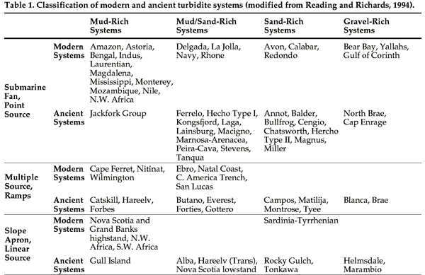
Deepwater mass movement sediments range form sand to mud prone and differences in their character are tied to the sediments eroded from their source terrain and the morphology of the depositional setting. This has resulted in Reading and Richards (1994) devising a classification scheme, seen in the cartoon above, for deepwater turbidite systems based on grain size and type of feeder system that further contrasts fine-grained and coarse-grained turbidite systems. The figure and table above divide these into the end members of fine grained turbidites systems and sand rich systems. To this end Stelting et al, (2000) have defined fine grained Deepwater Sediments as those that are composed of shale and/or silty mudstones with an equal or lesser thickness of sand-rich Beds for that particular turbidite system. Reading and Richards (1994) believe that if these finer sediments comprise at least 70% of the total succession, the system should be referred to as being "mud-rich". In contrast "sand-rich" systems are those that have a high net-to-gross ratio of sand and the shale Accumulations are much thinner than the sand-dominated successions (Bouma, 2000).
Stelting et al, (2000) have formalized how fine-grained, mud-rich turbidite systems are connected to large basins on passive margins. Sediment accumulation in these basins is associated with long terrestrial transport distances, a broad shelf, and deltas that provide sediment to that shelf. Sediment transport across the basin is efficient, driven by slope, tectonic movement and sea level change, so that a fair amount of the sand bypasses the fan to reach the outer fan, though net-to-gross ratio patterns vary across the fan. In contrast Stelting et al, (2000) recognize that coarse-grained, sand-rich turbidite systems are associated with smaller basins on continental crust with shorter terrestrial transport distances, a narrower shelves, canyon-sourcing, a nonefficient basin transportation system, a progradational depositional style, and a net-to-gross percentage that decreases laterally from the sediment transport pathway.
These observations match those of Nilson et al, (2006) who summarize how turbidite and other non-cohesive density flow sediments and mass-transport deposits (MTD) accumulate on different continental margins as functions of local and global controls.
It would appear that MTDs are favored by excessive local sediment sequestration within the adjacent shelf accompanied by slope failure. This is exemplified the character of the shelf margin in the Bering Sea. This area acted as a sink to glacial and volcanic sediments behaviour has been modulated by an active tectonic substrate and glacial eustasy. The result is a margin dominated by numerous giant, gullied canyons that act as conduits for MTDs with few associated turbidite systems (Nilson et al, 2006).
In contrast the Cascadia and San Andreas margins off North America have less sediment sequestrationso with the result that turbidites and other non-cohesive density flow sediments are the dominant deposits. In other areas where the tectonic and sedimentary history is variable, as in the vicinity of the Ebro deltaic complex of Spain, portions of the basin margin favor non-cohesive flow sediments alone while other segments only have aprons composed of MTDs (Nilson et al, 2006).
Large delta-fed passive margins commonly are associated with inter-mixed large and small scale MTDs and non-cohesive density flow sediments like turbidites. The Mississippi and Amazon provide examples of this, with their stratigraphic histories of varying rates of sediment supply. In the case of the Mississippi Fan the character of the intraslope mini-basins is additionally tied to salt tectonics. Large-scale up slope failures in conjunction with multiple failures of canyon and mini-basin walls fill the salt mini basins with sheets of MTD beds that are interbedded and also cover many associated fan channel-levee complexes (Nilson et al, 2006).
Climatic Events, particularly those related to glaciation, explain the massive MTDs of some the Antarctic margins, and the mixed MTDs and turbidites of others (Nilson et al, 2006). Also climatically driven lower sea levels in regions with temperate climates commonly produce lowstand MTDs (Nilson et al, 2006).
Click on highlighted Deepwater Gallery for access to a complete index to images, maps, diagrams and photographs of deepwater geology including the geology of Co Clare or access this gallery using the menu bar to the left side.
References Cited
Nilsen, Tor H., Gary S. Steffens, and Joseph J. R. Studlick, 2006, "Mass Transport Deposits in Deepwater Outcrops: Depositional Setting(s), Types, and Recognition", SEPM Research Symposium: The Significance of Mass Transport Deposits in Deepwater Environments II, AAPG Annual Convention, April 9-12, 2006 Technical Program
Reading, H. G., & Richards, M. (1994). "Turbidite systems in deep-water Basin margins classified by grain size and feeder system". Bull. Am. Ass. Petrol. Geol., 78, 792-822.
Stelting, C.E., A.H. Bouma, and C.G. Stone, 2000, Fine-Grained Turbidite Systems: Overview, in Fine-Grained Turbidite Systems/edited by A. H. Bouma and C. G. Stone. AAPG Memoir 72, SEPM Special Publication No. 68., p1-8
Stow, D.A.V., 1994. "Deep-sea processes of sediment transport and deposition. In: Sediment Transport and Depositional Processes", ed. by K. Pye, Blackwell Sci. Publ. pp 257-293.
Stow, D.A.V. and Mayall, M., editors, 2000. Deep-water Sedimentary Systems: Thematic Set, Marine and Petroleum Geology, Volume 17, No. 2.
USGS Coastal & Marine Geology Program Offices provide a number of extensive surveys of the continental margin of the USA.